Tag: map

  • The Last Train From Djibouti | Client: Otis Lee

    The Last Train From Djibouti | Client: Otis Lee

    Flyer for The Last Train From Djibouti. Graphic design by Scott DuBar.
    Flyer design for The Last Train from Djibouti, by author Otis Lee and published by Koehler Books.

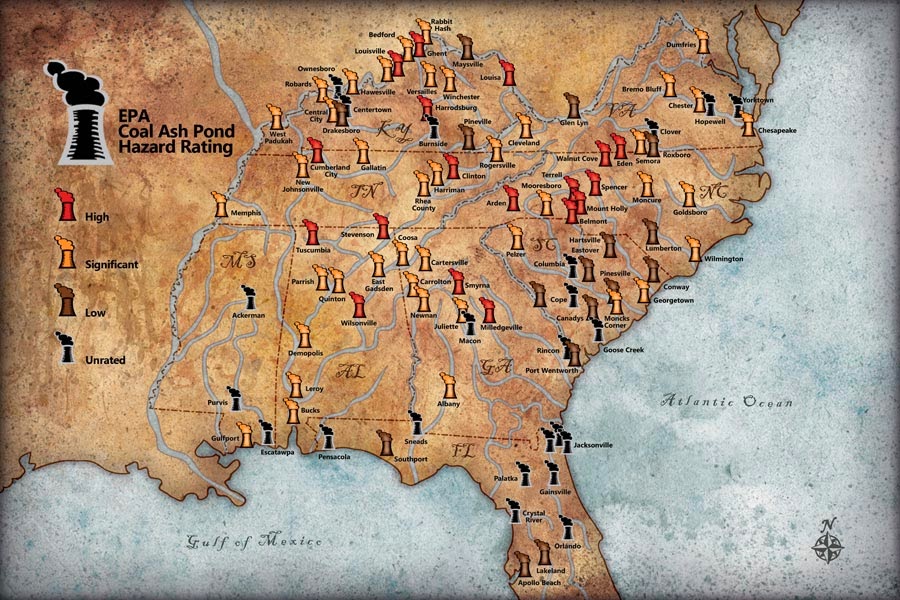
    Promotional designs for the launch of a new book by author Otis Lee titled The Last Train From Djibouti. Otis will be attending many book events and needed a variety of promotional items, from flyers (shown above) to bookmarks, business cards, and several event table displays. I was glad that Otis came to me with a clear idea for everything he needed to be designed as it made it easy for me to keep a consistent look for everything.

    Bookmark for The Last Train From Djibouti. Graphic design by Scott DuBar.
    Promotional bookmark design for author Otis Lee’s book The Last Train from Djibouti. Published by koehlerbooks.com.
    Business card for The Last Train From Djibouti. Graphic design by Scott DuBar.
    Promotional business card design for author Otis Lee’s book, The Last Train from Djibouti. Published by koehlerbooks.com.
    Illustrated map for The Last Train From Djibouti. Graphic design by Scott DuBar.
    Illustrated map of Africa. Highlights the train route taken from Djibouti to Ethiopia along with two other countries visited- Uganda and Botswana.

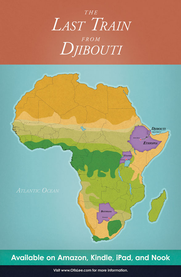
    The illustrated map of Africa was my personal favorite among the event table displays. Otis wanted something colorful that also highlighted both the train route they took as well as the various countries that they visited. My solution was to do a map featuring Africa’s temperate zones from arid to jungle while showing the visited countries in purple for nice color contrast. In addition to giving visual interest, it also helps give the viewer a better sense of what the landscape would look like for each of the places described in the book.

  • Coal Ash Ponds Map: Blue Ridge Outdoors

    Coal Ash Ponds Map: Blue Ridge Outdoors

    Map highlighting coal plants that pose a threat to local drinking water in and around the Blue Ridge Mountains. I was happy to learn that I don’t live near any coal ash ponds, but am quite sad to see just how many of these power plants pose a significant or higher hazard rating. I’m not sure how it works for the coal industry, but I generally want my clients to be healthy and happy and to feel good about the work I do for them. Remember kids: A living customer is a paying customer!

  • Road Trippin’ Maps for Blue Ridge Outdoors

    Road Trippin’ Maps for Blue Ridge Outdoors


    Here’s a couple of cartoon maps I did for the July issue of Blue Ridge Outdoors for an article highlighting various outdoorsy road trips along the Blue Ridge Mountains. The top map even includes my first-ever celebrity likeness, Paula Deen (y’all!), for her Savannah restaurant Lady and Sons.

  • Blue Ridge Outdoors: Appalachian Trail Map

    Blue Ridge Outdoors: Appalachian Trail Map

    My latest info map for Blue Ridge Outdoors Magazine.

  • Latest Map: The Great Eastern Trail

    Latest Map: The Great Eastern Trail

    Here’s my latest work for Blue Ridge Outdoors: a map of the Great Eastern Trail featuring some of the many highlights along the way.